India Weather Rollercoaster: Extreme Temperatures, Heavy Rains in South, and Rising Mercury in North – IMD Latest Forecast February 2026
India Weather: 37°C Heatwave Hits South, 8.7°C Freeze Shocks North
India is witnessing highly contrasting and dynamic weather patterns in late February 2026, as per the latest updates from the India Meteorological Department (IMD). From scorching highs in the south to chilly lows in the north, coupled with heavy rainfall warnings in southern states and potential thunderstorms in the east and hills, the country presents a classic case of seasonal transition mixed with active weather systems.
Extreme Temperature Contrasts Across the Country
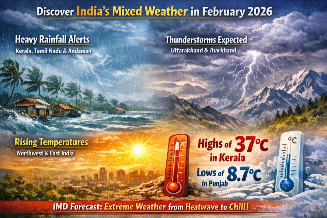
In the last 24 hours, Kottayam in Kerala emerged as the hottest spot with a maximum temperature soaring to 37.0°C, highlighting the early summer-like heat gripping parts of southern India. This stands in stark contrast to Amritsar in Punjab, which recorded the nation’s lowest minimum temperature at 8.7°C, underscoring the persistent cool spell in the northern plains influenced by recent western disturbances.
The IMD predicts a gradual rise in minimum temperatures nationwide in the coming days. Northwest India, including states like Punjab, Haryana, Rajasthan, and Delhi, could see an increase of 2–3°C over the next 7 days. Eastern India may experience a similar uptick of 2–3°C in the next three days. While no drastic shifts are expected in other regions, experts indicate stable conditions with minor fluctuations.
In Maharashtra, a slight dip in temperatures is anticipated over the next three days before a rebound in the following two. Gujarat is likely to see no significant change over the next five days. Overall, the country avoids major anomalies, but the north-south divide remains pronounced.
For residents in Guwahati and surrounding areas in Assam, the Guwahati Regional Meteorological Centre forecasts partly cloudy skies today (Saturday, February 21, 2026), with no active weather warnings. Maximum temperatures are expected around 33°C, while minima hover near 16°C — comfortable conditions with no rainfall anticipated in Assam districts today or tomorrow (Sunday).
Heavy Rainfall and Thunderstorms Batter Southern India
Southern India faces an active spell driven by weather systems in the Bay of Bengal and adjoining Indian Ocean. A low-pressure area persists over the southwest Bay of Bengal, gradually weakening, while a new one is forming over the southeast Bay of Bengal and nearby seas, moving northward to north-westward.
Heavy rainfall is very likely at isolated places over south Tamil Nadu, south Kerala, and Mahe on February 21 and 22, 2026. Alerts extend to Tamil Nadu, Puducherry, Karaikal, Kerala, and Mahe, with thunderstorms, lightning, and gusty winds (30–40 km/h) probable. The Andaman and Nicobar Islands may see heavy downpours starting Saturday, with continued activity into the weekend.
This system has prompted yellow alerts in several southern districts, including parts of Tamil Nadu (e.g., Kanyakumari, Tirunelveli) and Kerala (e.g., Pathanamthitta, Kottayam, Idukki). Fishermen are advised against venturing into rough seas in the southwest Bay of Bengal and adjoining Indian Ocean, where winds reach 40–45 km/h, gusting to 55 km/h.
Light to moderate rainfall with thunderstorms is expected over south interior Karnataka (February 21–24) and coastal/north interior Karnataka (February 22–24). Isolated heavy falls could disrupt travel, agriculture, and daily life in these regions.
Thunderstorms and Rainfall in Eastern and Himalayan Regions
Moving northward, Uttarakhand and Himachal Pradesh face thunderstorm risks on February 23 and 24 (Monday and Tuesday). Similar conditions are likely in Jharkhand and Odisha during the same period, with possible hail in isolated spots as per broader IMD outlooks.
Southern West Bengal districts may receive light to moderate rainfall on February 23 and 24. A subtropical westerly jet stream over northeast India’s coastal areas, combined with a cyclonic circulation possibility over Assam and the northeastern region, adds to the instability.
An axis from the southwest Bay of Bengal to Lakshadweep passes over Tamil Nadu and Kerala, while another stretches from Gujarat to Haryana, influencing widespread patterns.
In Assam, the Regional Meteorological Centre confirms no rainfall today or tomorrow across any district. However, isolated light rain is possible Monday in Tinsukia, Dhemaji, Lakhimpur, and Dima Hasao districts.
Key India Weather Systems Driving the Changes
- Western Disturbance Influence: Active over western Rajasthan, Punjab, and Haryana, with another entering northwest India on February 22 (Sunday). This could bring scattered light rainfall/snow in western Himalayas later.
- Bay of Bengal Low-Pressure Areas: Continuous formation in southern regions fuels southern rains, while weakening systems reduce intensity gradually.
- Cyclonic Circulation and Axes: Potential over northeast, with axes enhancing moisture convergence in south and west.
These systems explain the mixed bag: cool northern remnants, warming trends, and southern convective activity typical of pre-summer transitions.
Implications and Safety Advice
Farmers in southern states should prepare for waterlogging and crop impacts from heavy rains. Northern residents may enjoy milder mornings as minima rise. Travelers to hills or coasts need caution for thunderstorms and rough seas.
The IMD continues monitoring, with extended forecasts indicating no major heatwaves yet, though February trends show above-normal maxima in parts.
This comprehensive update on India’s February 2026 weather — from Kerala-Tamil Nadu heavy rain alerts to northwest temperature rises — highlights the nation’s diverse climatic zones. Bookmark for daily IMD-based insights.