Cyclone Arnab Makes Landfall in Andhra Pradesh: 3 Dead, Over 1 Lakh Evacuated Amid Fierce Winds and Flooding
Cyclone Arnab, the powerful very severe cyclonic storm that developed over the Bay of Bengal, made landfall along India’s eastern coast in the early hours of Wednesday, October 28, 2026, unleashing destructive winds, torrential rainfall, and widespread disruption across Andhra Pradesh and neighbouring Odisha. Classified by the India Meteorological Department (IMD) as a very severe cyclonic storm—the third-highest category on its scale—the system crossed the Andhra Pradesh–Yanam coast near Narsapur in West Godavari district with maximum sustained winds of 125–135 kmph and gusts reaching 150 kmph.
As of the latest reports, at least three people have lost their lives in Andhra Pradesh, more than 87,000 to over 180,000 people were evacuated to safer locations depending on different official tallies, hundreds of trees were uprooted, power supply was disrupted in multiple districts, and standing crops and houses suffered damage. No major casualties were reported in Odisha, though the state remained on high alert for heavy rain and possible landslides in southern districts.
Formation and Intensification of Cyclone Arnab
Cyclone Arnab originated as a low-pressure area over the east-central and south-east Bay of Bengal. It intensified into a depression, then a deep depression, before strengthening into a cyclonic storm on October 26, 2026. The system moved west-northwestwards and rapidly gained strength, becoming a severe cyclonic storm and then a very severe cyclonic storm.
The name “Arnab” was proposed by Bangladesh under the World Meteorological Organization (WMO) and United Nations Economic and Social Commission for Asia and the Pacific (ESCAP) naming convention for North Indian Ocean cyclones. In Bengali, Arnab means “ocean” or “sea” and is pronounced “Ornab.”
Satellite imagery revealed the storm’s immense scale, with its cloud cover extending across a large portion of the Indian landmass even as the core approached the coast. Some analyses noted rapid intensification, raising questions about factors such as warm sea surface temperatures that may have contributed to its strength, though official IMD bulletins focused on observed track and intensity.
The cyclone remained practically stationary off the Andhra Pradesh coast for a period before completing landfall. The process began around 1:20 a.m. IST on October 28 and continued for several hours, with the centre moving fully inland by mid-morning. After landfall, it weakened into a severe cyclonic storm.
Landfall Details and Immediate Impact
According to IMD hourly bulletins, Cyclone Arnab crossed the coast approximately 20 km east-northeast of Narsapur, 40 km southwest of Yanam, and 60 km southwest of Kakinada. Wind speeds during landfall reached 125–135 kmph, with gusts up to 150 kmph. A storm surge of up to 1–1.5 metres above normal tide levels was forecast, threatening low-lying coastal areas.
Heavy to extremely heavy rainfall lashed coastal and adjoining districts. Recorded amounts included over 200 mm in multiple locations within short periods. Specific readings highlighted by agencies included Kannuripalem in Anakapalli (around 261 mm), areas in Vizianagaram exceeding 250 mm, and significant totals in Visakhapatnam, Kakinada, Konaseema, and Srikakulam. Some stations reported 25–26 cm of rain.
In Andhra Pradesh, the hardest-hit districts included Visakhapatnam, Anakapalli, Vizianagaram, Kakinada, West Godavari, and Konaseema. Fallen trees blocked highways, electric poles snapped, and power outages affected large areas. At least 31 houses were damaged in initial assessments, with reports of up to 180 houses affected and around 220 trees brought down in broader tallies shared by state officials. Crops in coastal agricultural belts suffered damage from wind and waterlogging.
Three deaths were confirmed in Andhra Pradesh. One 46-year-old man died after a tree fell on him in Bhimavaram, West Godavari district. Two other fatalities were linked to electrocution from snapped live wires. Authorities emphasised that timely evacuations prevented a higher toll.
Massive Evacuations and Preparedness
Authorities in Andhra Pradesh and Odisha conducted large-scale pre-emptive evacuations. Figures varied slightly across reports but consistently showed tens of thousands moved to safety: approximately 57,000 to over 84,000 in Andhra Pradesh and more than 30,000 in Odisha, with some combined totals exceeding 1 lakh and higher estimates approaching 1.8 lakh. Low-lying areas, coastal villages, and vulnerable populations—including women, children, the elderly, and pregnant women—were prioritised.
Relief camps were set up, and National Disaster Response Force (NDRF), State Disaster Response Force (SDRF), and local emergency teams were fully activated. The Indian Air Force conducted sorties to deploy additional NDRF teams. Fishing boats were brought ashore well in advance, with thousands of vessels secured along the coast.
Andhra Pradesh Chief Minister N. Chandrababu Naidu reviewed the situation through teleconferences involving thousands of officials and directed immediate clearance of roads, restoration of power, and continuous monitoring. He communicated updates to Union Home Minister Amit Shah. Schools were closed in affected areas, and residents were advised to stay indoors until conditions improved.
In Odisha, southern districts such as Malkangiri, Koraput, Rayagada, Gajapati, and Nabarangpur were placed on high alert for heavy rainfall and landslide risks. Evacuations focused on vulnerable pockets.
Disruption to Transport and Daily Life
Transport networks faced significant disruption. South Coast Railway cancelled dozens of trains (reports mentioned 57 cancellations and 15 reschedulings) and suspended services on multiple routes as a precaution. Flights at airports in Andhra Pradesh, including Visakhapatnam, were affected, with operations suspended or delayed.
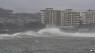
Road connectivity suffered from fallen trees and flooding in low-lying stretches. In urban centres like Visakhapatnam and Kakinada, residents navigated waterlogged streets, and rescue teams assisted stranded individuals. Visuals from the ground showed high waves battering the coast, uprooted trees, damaged vehicles, and people using plastic sheets for protection against the rain and wind.
Power supply interruptions impacted communication and daily activities. Restoration teams were mobilised as soon as weather conditions allowed.
Broader Effects and Regional Concerns
Beyond the immediate coastal impact, the cyclone’s outer bands brought rain to wider areas. Authorities in neighbouring regions monitored the system’s inland movement, which was expected to continue northwestwards initially before weakening further. In Nepal, warnings were issued for high-altitude areas due to the potential for heavy precipitation, snow, and avalanche risks in the coming days linked to the remnant moisture.
More than 12 million people lived in the broader path of the storm system according to early assessments. Historical data helped identify vulnerable locations for targeted evacuations, contributing to the relatively contained loss of life despite the storm’s intensity.
Relief Operations and Recovery Underway
As the cyclone weakened after landfall, focus shifted to relief and restoration. NDRF Inspector General N.S. Bundela confirmed Andhra Pradesh as the worst-affected state and noted that teams were actively engaged. Power restoration, road clearance, and assessment of crop and property damage were prioritised.
Chief Minister Naidu directed officials to ensure no shortages of essentials in relief camps and to expedite help to affected families. Medical teams were on standby, and historical vulnerability mapping guided the response.
Residents in places like Kakinada described the anxiety of rising water and uncertainty about which homes would be inundated. Community cooperation and early warnings played a key role in minimising harm.
Understanding Cyclone Intensity and Future Outlook
Under the IMD classification, a very severe cyclonic storm features sustained winds in the 119–165 kmph range. Cyclone Arnab peaked near the upper end of the lower portion of this category with gusts higher. Rapid intensification episodes over warm Bay of Bengal waters remain a challenge for precise forecasting, as noted in meteorological discussions around the event.
The system was expected to continue weakening while moving inland, bringing residual heavy rainfall to parts of Andhra Pradesh, Odisha, and possibly further north for a day or two. Residents were advised to remain cautious of waterlogging, damaged infrastructure, and secondary hazards such as electrocution risks from downed lines.
Lessons from Cyclone Arnab
The event underscored the importance of robust early warning systems, coordinated multi-agency response, and public compliance with evacuation orders. India’s disaster management framework—involving IMD forecasts, NDRF/SDRF deployment, state administrations, and community participation—helped limit the human cost relative to the storm’s strength.
Ongoing assessments will quantify the full economic impact on agriculture, infrastructure, and livelihoods in the coastal belt. Long-term measures such as improved coastal resilience, better power infrastructure hardening, and enhanced forecasting of rapid intensification will remain priorities for the region, which faces recurrent Bay of Bengal cyclone threats.
For the latest official updates, residents and interested parties should refer to IMD bulletins, state disaster management authority advisories, and verified government channels. Recovery efforts are expected to intensify in the coming days as weather conditions stabilise.
Cyclone Arnab has once again demonstrated both the destructive power of tropical systems in the Bay of Bengal and the effectiveness of preparedness in saving lives. As Andhra Pradesh and Odisha begin the task of rebuilding, the focus remains on supporting affected communities and restoring normalcy as swiftly as possible.